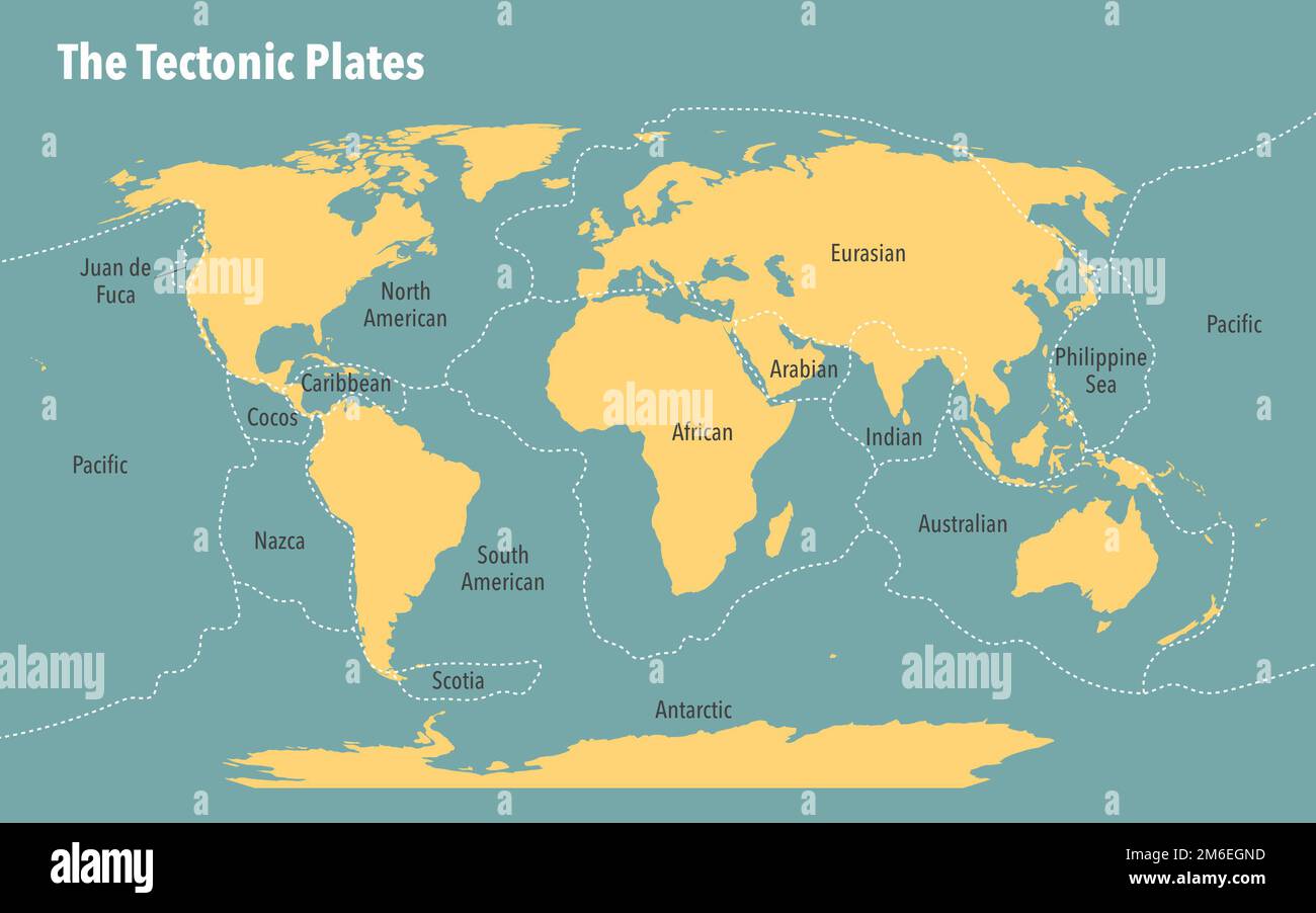
You probably remember that colorful poster in the back of your 9th-grade earth science classroom. It looked like a giant, cracked jigsaw puzzle. Most of us just memorized the names—Pacific, North American, African—and went back to daydreaming. But honestly, if you look at a modern tectonic plate map of the world, it’s not just a static drawing. It’s a dynamic, high-stakes blueprint of where the Earth is literally ripping itself apart or crushing itself into powder.
Most people think of plates as these massive, slow-moving rafts. While that's basically true, the real story is in the "micro-plates" and the weird zones where nobody can quite agree on where one ends and another begins. The Earth isn't just seven or eight big pieces. It’s a mess.
The Messy Reality of the Tectonic Plate Map of the World
When you first glance at a tectonic plate map of the world, the "Major Seven" dominate the view. You've got the African, Antarctic, Eurasian, Indo-Australian, North American, Pacific, and South American plates. They’re the heavy hitters. But scientists like those at the United States Geological Survey (USGS) have identified dozens of smaller "minor" and "micro" plates that make things complicated.
Take the Juan de Fuca plate off the coast of the Pacific Northwest. It’s tiny compared to its neighbor, the Pacific plate, but it’s the reason Seattle and Portland are sitting on a literal powder keg. Or look at the Mediterranean. It’s a nightmare of fragmented crustal blocks. You can’t just draw a single clean line there and call it a day.
Why the Lines Keep Moving
The boundaries on these maps aren't just lines; they're war zones. We categorize them into three main flavors:
- Divergent boundaries: This is where the Earth is making new "skin." Think of the Mid-Atlantic Ridge. The Atlantic Ocean is actually getting wider by about 2.5 centimeters every year. It’s slow, sure, but over millions of years, that’s how you get an entire ocean.
- Convergent boundaries: These are the "crunch zones." One plate dives under another (subduction) or they smash together to build mountains. The Himalayas are the result of the Indo-Australian plate slamming into the Eurasian plate. It's still happening. Everest is actually getting taller.
- Transform boundaries: These plates just want to slide past each other. The San Andreas Fault is the poster child here. No new crust is made, none is destroyed, but the friction is enough to level a city when the tension finally snaps.
The Ring of Fire: Where the Map Gets Loud
If you overlay a map of every major earthquake and volcano over a tectonic plate map of the world, the dots line up almost perfectly with the edges of the Pacific Plate. This is the Ring of Fire. It’s a 40,000-kilometer horseshoe of pure geological chaos.
About 90% of the world's earthquakes happen here. Why? Because the Pacific Plate is basically being surrounded. It’s being shoved under South America, North America, Japan, and the Philippines. When you see a map showing these subduction zones, you're looking at the most dangerous real estate on the planet.
It’s not just about disaster, though. These plate movements are why we have certain minerals and fertile volcanic soil. Life sort of clings to these cracks in the Earth because that's where the nutrients from deep inside the planet get recycled back to the surface.
The "Micro-Plate" Problem and Scientific Debate
Geology isn't a settled science. Not by a long shot. If you talk to a geophysicist, they might tell you that the Indo-Australian plate is actually two separate plates—the Indian and the Australian—that are slowly breaking apart.
There's also the Lwandle Plate, a "micro-plate" near Madagascar that most people have never heard of. Or the Gorda Plate. Mapping these out isn't just academic. If we don't know exactly where the breaks are, we can't predict where the next 8.0 magnitude quake is going to start.
The East African Rift is another weird one. Usually, we think of the African Plate as one big unit. But it’s actually splitting. In a few million years, the eastern part of Africa will be its own island, and a new ocean will fill the gap. You can literally go to Ethiopia and see giant cracks opening up in the ground where the continent is pulling itself into two pieces.
How to Actually Use This Information
Knowing the layout of a tectonic plate map of the world isn't just for trivia night. It has massive implications for global trade, infrastructure, and safety.
- Real Estate and Insurance: If you're buying property in places like California, Chile, or Japan, you are essentially betting against the map. Insurance companies use these tectonic models to set premiums. If you live near a "triple junction" (where three plates meet), your rates are going to reflect that risk.
- Infrastructure Design: Engineers don't just build bridges; they build "seismic-ready" structures. In places like Istanbul—which sits dangerously close to the North Anatolian Fault—engineers have to design buildings that can sway or slide during a quake rather than snap.
- Natural Resource Hunting: Gold, copper, and silver deposits are often found near ancient or active plate boundaries. Magma rising through the crust carries these metals with it. If you’re in the mining business, the tectonic map is your treasure map.
The Future of the Map
Plate tectonics is a relatively new theory. It wasn't even widely accepted until the 1960s. Before that, scientists thought the continents were stuck in place or that the Earth was expanding like a balloon.
Today, we use GPS satellites to track plate movement in real-time. We can see the North American plate moving west-southwest at about the same speed your fingernails grow. It’s wild to think that the entire map of the world we see today is just a single frame in a movie that’s been playing for 4 billion years.
Eventually, all the continents will probably smash back together into a new supercontinent, often called "Pangea Proxima" or "Amasia." But don't cancel your vacation plans just yet—that won't happen for another 250 million years.
Practical Next Steps for the Curious
If you want to go deeper than just looking at a static image, there are some incredible tools available right now.
Check out the Iris Earthquake Browser. It lets you see every earthquake that happened in the last 24 hours overlaid on a plate map. It’s a sobering way to see how much the Earth is actually moving while you’re sitting at your desk.
You can also look into the "PALEOMAP Project" by Christopher Scotese. He’s done incredible work animating how the plates have moved over the last 500 million years and where they are likely headed.
Understanding the tectonic plate map of the world is basically understanding the engine of the planet. It’s messy, it’s constantly being revised, and it’s the reason the world looks the way it does. Stay curious about the ground beneath your feet—it’s moving a lot more than you think.
Actionable Insights:
- Use interactive tools like USGS Latest Earthquakes to see real-time plate activity.
- Research local fault lines if you live in a coastal or mountainous region.
- Understand that plate maps are updated as satellite data improves; always look for the most recent geological surveys.