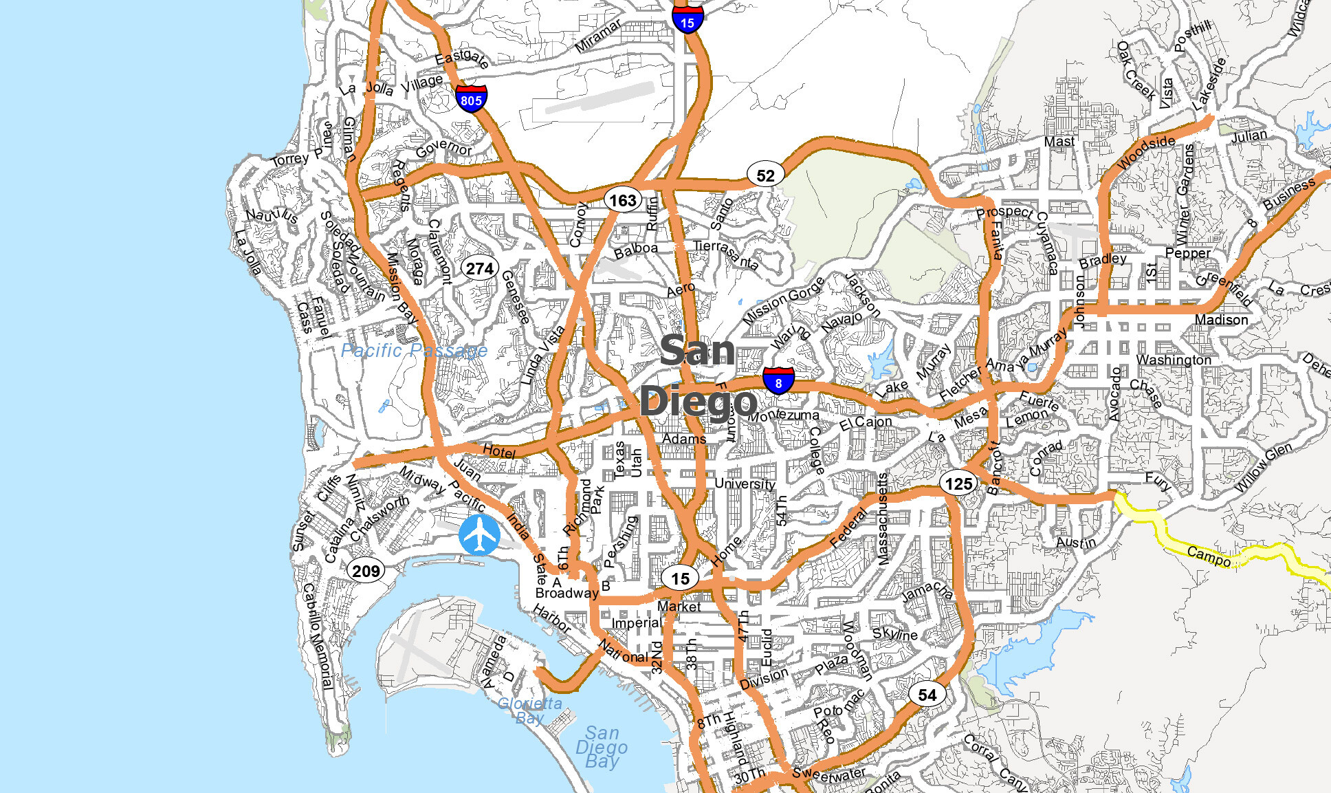
San Diego is massive. If you’re staring at a map of San Diego California for the first time, it’s easy to feel like you’re looking at a tangled ball of yarn. Most people think it’s just a beach town, but the geography tells a much weirder, more vertical story. You have the Pacific Ocean to the west, Mexico just a stone’s throw to the south, and mountains that actually get snow to the east.
It's a lot.
Honestly, the way the city is laid out is a bit of a headache for newcomers. The "mesa" system means you can be looking at a building across a canyon that's only 200 yards away, but it'll take you fifteen minutes to drive there because you have to go all the way around the rim. That’s why understanding the map isn't just about knowing north from south; it’s about understanding the "neighborhood clusters" that define the culture here.
The Coastal Strip: More Than Just Sand
When people search for a map of San Diego California, they’re usually looking for the coast. It’s the money shot. But even the coastline is split into distinct personalities.
Starting up north, you’ve got La Jolla. On a map, it looks like a thumb sticking out into the ocean. It’s hilly, expensive, and home to the University of California San Diego (UCSD). If you look closely at the topography near the Salk Institute, you’ll see the deep canyons that make hiking here a leg-burning nightmare.
Move south on the map and you hit Pacific Beach and Mission Beach. This is the "fun" part. It’s a literal sandbar. Mission Bay is a man-made aquatic park that looks like a giant puzzle piece carved out of the land. It’s where people go to paddleboard without getting smashed by waves. Further south is Point Loma, which acts as a massive natural breakwater for the San Diego Bay. Without that giant ridge of land, the U.S. Navy wouldn’t have such a perfect, protected harbor.
Why the Downtown Grid is Actually Helpful
San Diego’s downtown is one of the few places in the county where the map actually makes sense. It’s a grid. Mostly.
The Gaslamp Quarter is the heart of it. If you’re looking at a map of San Diego California’s urban core, you’ll notice it’s pinned between the San Diego Bay and Balboa Park. Balboa Park is the "Central Park" of the West, but it’s arguably cooler because it has a world-famous zoo and Spanish Colonial Revival architecture that looks like a movie set.
South of downtown, you cross the San Diego-Coronado Bridge. It’s that giant blue curve on the map. Fun fact: the bridge is high enough to let aircraft carriers pass underneath. Coronado itself isn't technically an island—it's a "tied island" connected to the mainland by a thin, seven-mile strip of sand called the Silver Strand. If you're driving it, keep your eyes on the road; the wind gets wild.
The Inland Empire (The San Diego Version)
Once you move east of Interstate 15, the map of San Diego California changes completely. The ocean breeze dies. The temperature jumps ten degrees.
Neighborhoods like North Park and South Park are the "hip" spots right now. They sit on the mesas overlooking the canyons. If you go further east, you hit the foothills. Places like El Cajon and Santee are tucked into valleys. The map here is dominated by "v" shapes—these are the canyons that carry runoff from the mountains down to the sea.
People forget that San Diego County is one of the most biologically diverse counties in the United States. We have everything from desert scrub to pine forests. If you follow Highway 78 or the 8 Freeway far enough east on your map, you’ll climb thousands of feet in less than an hour. You go from surfing at 10:00 AM to seeing snow in Julian by noon. It's a topographical flex that most cities can't match.
Navigating the Freeway "Spaghetti"
Look at any map of San Diego California and you’ll see the "Big Three" vertical lines: the 5, the 805, and the 15.
The 5 is the coastal artery. It’s beautiful, it’s iconic, and it’s usually a parking lot during rush hour. The 805 is the bypass that somehow ended up being just as crowded. The 15 is the gateway to the "inland" world, stretching all the way up to Riverside County.
Then you have the 8. It’s the main east-west horizontal line. It follows the path of the San Diego River. If you’re trying to get from the beaches to the mountains, the 8 is your best friend. But be careful near the "Mission Valley Interchange" where the 8 and the 163 meet. The 163 is actually a historic parkway that winds through Balboa Park under high-arched bridges. It's easily the prettiest stretch of road in the city, but the merge lanes are short and terrifying.
Border Dynamics and the South Bay
You can't talk about a map of San Diego California without mentioning the international border. San Ysidro is the busiest land border crossing in the world.
The South Bay—places like Chula Vista and Imperial Beach—has a vibe that is inextricably linked to Tijuana. The geography here is flatter, dominated by the salt works and the wildlife refuge. If you look at the very bottom of the map, you’ll see the Tijuana River Estuary. It’s one of the few remaining salt marshes in Southern California. It’s a vital ecological spot, though it unfortunately struggles with pollution issues whenever it rains heavily.
Hidden Gems on the Map
Most tourists miss the stuff that locals love.
- Mount Soledad: It’s the highest point in La Jolla. On a clear day, the map comes to life. You can see all the way to Mexico and the Channel Islands.
- Torrey Pines State Natural Reserve: On the map, it’s just a green patch north of La Jolla. In reality, it’s a prehistoric landscape with trees that don’t grow anywhere else on Earth.
- The 7 Bridges Walk: This is a DIY urban hike that takes you through the older parts of the city (Hillcrest, Bankers Hill). It’s the best way to understand how the "mesa and canyon" geography works on foot.
Final Logistics and Actionable Advice
If you’re planning a trip or a move, don't just trust the GPS "time to destination." A map of San Diego California is deceptive because of the terrain. A five-mile trip can take thirty minutes if you have to cross three different canyons and two freeways.
What to do next:
- Download offline maps: If you’re heading into the east county mountains (like Anza-Borrego or Cuyamaca), cell service is non-existent.
- Check the "Microclimate" forecast: San Diego isn't one temperature. Check the weather for the specific neighborhood on the map you’re visiting. Del Mar might be 65°F and foggy, while Escondido is 90°F and sun-scorched.
- Use the Trolley for Downtown/South Bay: The Blue Line trolley is actually pretty great now. It runs from the border all the way up to UCSD. It saves you the nightmare of $40 parking in the Gaslamp.
- Explore the "Old Highway 101": Instead of staying on the Interstate 5, look for the coastal road on your map. It takes you through the heart of surf towns like Encinitas and Solana Beach. It’s slower, but it’s the "real" San Diego.
Understanding the layout of this city takes time. It’s a weird mix of military bases, luxury hillsides, and rugged backcountry. But once you get the hang of how the mesas connect to the valleys, the whole place starts to feel a lot smaller and much more accessible.