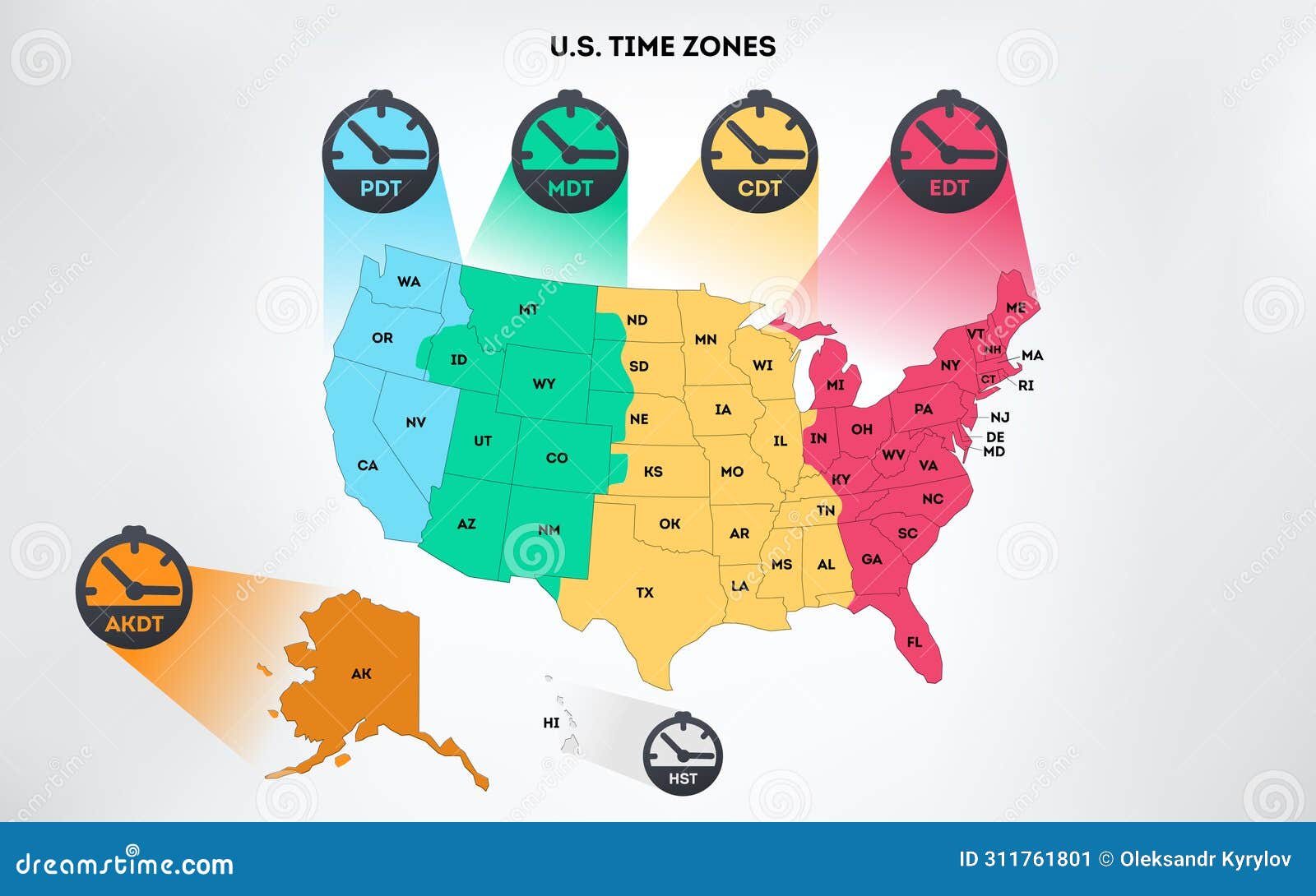
Ever tried calling your cousin in Seattle from a hotel room in New York, only to realize you’ve woken them up at 5:00 AM? It happens. Honestly, figuring out what are the time zones in the USA is one of those things that seems simple until you're staring at a map of Arizona or trying to schedule a Zoom call across three states. Most people think there are four. Some say six. If you’re being technical and counting the territories, the number jumps even higher.
It’s a mess of invisible lines.
The United States isn't just one big block of time. It’s a jagged, slightly confusing patchwork that shifts twice a year for most of us, thanks to Daylight Saving Time. But if you want the short answer, the 48 contiguous states are split into four main slices: Eastern, Central, Mountain, and Pacific.
The Big Four: Where Most Americans Live
Let's start with the heavy hitters. Eastern Time (ET) is the big one. It covers almost half the population. If you’re in NYC, DC, or Miami, you’re in the zone that dictates when the evening news starts and when the stock market opens. It's $UTC-5$ normally, but it jumps to $UTC-4$ in the summer.
Then you move one step left on the map to Central Time (CT). Think Chicago, Dallas, and New Orleans. It’s exactly one hour behind the East Coast. People here get used to seeing "8/7c" on TV promos. It’s a massive zone that stretches from the Canadian border all the way down to the Gulf of Mexico.
Mountain Time (MT) is where things get weird. It covers the Rockies—Denver, Phoenix, Salt Lake City. It’s two hours behind the East. But wait. Arizona is in Mountain Time, yet they don't do Daylight Saving. So for half the year, they’re basically on the same time as California, and for the other half, they’re with Colorado. It's a headache for planners.
Finally, you’ve got Pacific Time (PT). Los Angeles, San Francisco, Seattle. Three hours behind New York. When the sun is setting in Manhattan, people in Santa Monica are still finishing their late lunches.
Beyond the Lower 48
If you think those four cover everything, you’re missing a huge chunk of the country. Alaska and Hawaii don't fit into that neat little four-zone box.
Alaska Time is four hours behind the East Coast. But Alaska is so big that it actually needs more than one zone. Most of the state uses Alaska Time, but the Aleutian Islands—that long string of islands pointing toward Russia—actually use Hawaii-Aleutian Time.
Speaking of Hawaii, they have their own thing. Hawaii-Aleutian Standard Time (HST) is five hours behind the East Coast during the winter. Because Hawaii is so close to the equator, they don't bother with Daylight Saving Time. Why would they? The sun stays up plenty long enough. This means that during the summer, when the rest of the US "springs forward," Hawaii ends up six hours behind New York.
The Territories and the "Secret" Zones
If we are being absolute sticklers for accuracy regarding what are the time zones in the USA, we have to talk about the territories.
- Atlantic Standard Time (AST): This covers Puerto Rico and the U.S. Virgin Islands. They are one hour ahead of Eastern Standard Time. They don't do Daylight Saving either.
- Samoa Standard Time: Used in American Samoa.
- Chamorro Standard Time: Used in Guam and the Northern Mariana Islands.
If you include these, the U.S. technically operates across nearly 11 different time zones depending on how you count the uninhabited islands like Baker Island and Howland Island (which sit in the furthest reaches of the Western Hemisphere).
Why do the lines look so jagged?
Look at a time zone map. The lines aren't straight. They don't follow longitudes perfectly. Instead, they zig-zag around county lines and state borders.
Why? Politics and pocketbooks.
The Department of Transportation (DOT) actually oversees time zones in the U.S. That sounds strange, right? But it makes sense when you realize time zones were popularized by the railroads. Before 1883, every town kept its own "local mean time" based on the sun. It was chaos for train schedules. To prevent trains from crashing into each other, the industry forced a standardized system.
The DOT keeps the power to move the lines today. Usually, a town or county will petition to move into a different zone if most of their business happens in a neighboring state. For example, parts of North Dakota and South Dakota are split between Central and Mountain time because the western halves of those states are more culturally and economically tied to the mountain region.
The Arizona and Indiana Oddities
Arizona is the rebel of the lower 48. Except for the Navajo Nation (which does observe Daylight Saving), the state stays on Standard Time year-round. It’s too hot there to want an extra hour of evening sunlight. If the sun stayed out until 9:00 PM in a Phoenix July, the electricity bills for air conditioning would bankrupt everyone.
Indiana used to be even more confusing. Until 2006, only some parts of the state observed Daylight Saving Time while others didn't. It was a nightmare for shipping companies like FedEx and UPS. Eventually, the state legislature stepped in and forced everyone to sync up, though the state remains split between the Eastern and Central zones.
Managing the Time Gap in Real Life
If you’re traveling or working remotely, the "time zone math" is a skill you have to master.
- The "Double Check" Rule: Always verify if your destination observes Daylight Saving. If you're flying into Phoenix in July, don't assume they shifted their clocks with you.
- The 3-Hour Rule: When working across the coast, the "golden window" for meetings is usually 11:00 AM to 2:00 PM ET. That’s when the East Coast is back from lunch and the West Coast has finally had their coffee.
- Digital Tools: Use the "World Clock" on your phone. It sounds obvious, but adding "Phoenix," "Chicago," and "Honolulu" to your favorites prevents about 90% of scheduling errors.
Actionable Takeaways for Navigating US Time
Understanding the layout is just the start. To actually function across these zones without losing your mind, keep these specifics in mind:
- Check the DOT Maps: If you are moving to a border town (like those in Nebraska or Kentucky), check the official Department of Transportation maps. The "wall" between zones can literally run down the middle of a street.
- Acknowledge the "Spring Forward": Daylight Saving Time starts on the second Sunday in March and ends on the first Sunday in November. Mark these. If you have a flight on those Sundays, your internal clock will be wrong.
- Territory Timing: If you're doing business with Puerto Rico or Guam, remember they are "fixed." They don't move. Their relationship to your local clock will change twice a year even though theirs stays the same.
The U.S. time system is a relic of railroad history and local preference. It’s not perfect, and it’s certainly not straight, but once you realize it's all about commerce and sunlight, the jagged lines start to make a lot more sense.