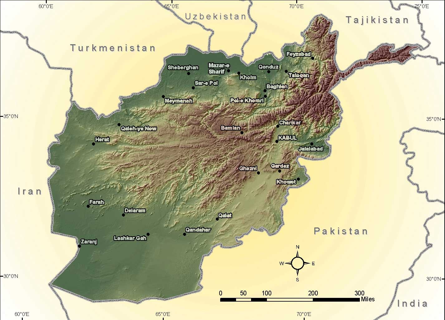
Honestly, if you look at a map of Afghanistan in Asia, it looks like a puzzle piece that someone forced into the wrong spot. It’s tucked right where Central Asia, South Asia, and the Middle East all collide. No ocean. No easy exits. Just 252,000 square miles of some of the most unforgiving, rugged terrain on the planet.
People call it the "Heart of Asia." That sounds poetic, but for the folks living there, it’s a logistical nightmare. You've got six neighbors—Pakistan, Iran, Turkmenistan, Uzbekistan, Tajikistan, and China—and almost every single one of those borders is a flashpoint for something, whether it's smuggling, water rights, or ancient territorial beef.
The Giant Spine in the Middle
Everything about Afghanistan’s geography starts and ends with the Hindu Kush. This mountain range is basically the country's backbone. It slices through the center, stretching from the northeast down toward the southwest.
It’s not just a bunch of hills. We’re talking about peaks like Noshaq, which towers at over 24,000 feet. Because of these mountains, the country is split into three distinct zones:
- The Northern Plains: This is where the agriculture happens. It’s relatively flat and connects toward the Central Asian steppes.
- The Central Highlands: Deep valleys, sharp gorges, and absolute isolation.
- The Southwestern Plateau: Mostly desert. It’s hot, dry, and home to the massive Helmand River.
Because the mountains are so big and the roads are so bad, a village on one side of a ridge might as well be on another planet from a village on the other side. That’s why centralizing power in Kabul has been a failing mission for about a thousand years.
That Long, Messy Border With Pakistan
If you scan the map, the longest line you'll see is the eastern and southern border with Pakistan. It’s about 1,600 miles long and is known as the Durand Line.
Here’s the thing: Afghanistan doesn’t actually recognize it.
Back in 1893, a British guy named Sir Mortimer Durand drew this line to separate British India from Afghanistan. He didn't really care that he was cutting right through the middle of Pashtun tribal lands. Fast forward to 2026, and it’s still a mess. Just recently, the Taliban government released a "Greater Afghanistan" map that includes chunks of Pakistani territory. It’s a bold move that has Islamabad—and the rest of the region—on edge.
Border crossings like Torkham and Spin Boldak are the lifeblood of the economy. When they shut down because of a skirmish or a political spat, prices for flour and oil in Kabul skyrocket within forty-eight hours.
The Wakhan Corridor: A 47-Mile Miracle
There is a tiny, weird-looking finger of land pointing east toward China. That’s the Wakhan Corridor. It exists solely because the British and Russians didn't want their empires to touch in the 1800s. They created this "buffer zone" so there would be a thin strip of Afghan land between them.
It’s incredibly remote. There are people living there who didn't even know about the wars in the rest of the country for years. Even though it gives Afghanistan a 47-mile border with China, there’s no paved road through the Wakhjir Pass. It’s basically just high-altitude trekker territory, though there have been constant rumors about China finally building a road to tap into Afghanistan’s trillions of dollars worth of minerals.
Why the Neighbors Are Nervous
When you’re landlocked, your neighbors are your only hope for trade. But it's complicated.
- Iran (West): They share the Helmand River. When Afghanistan builds dams to help their own farmers, Iran gets angry because their wetlands downstream dry up.
- The "Stans" (North): Turkmenistan, Uzbekistan, and Tajikistan are the gateways to the north. There’s a huge bridge over the Amu Darya river (the Friendship Bridge) that connects to Uzbekistan. It's the main route for fuel and electricity.
- The Water Problem: Afghanistan is actually water-rich because of the snowmelt in the Hindu Kush, but they don't have the tech to keep it. Most of it just flows out to Pakistan and Iran for free.
Actionable Insights for Navigating the Map
If you’re trying to understand the current situation, don't just look at the political borders. Look at the topography.
- Watch the passes: Keep an eye on the Salang Pass. It’s the only major tunnel through the Hindu Kush. If that tunnel closes (due to snow or conflict), the country is effectively cut in half.
- Follow the trade routes: Since the Pakistan border is so volatile, watch for the shift toward Chabahar Port in Iran. If Afghanistan successfully reroutes its trade through Iran and India, the power dynamic in the region shifts completely.
- Check the snowpack: 2026 is looking like a dry year. Without heavy snow in the mountains, the spring floods won't happen, and the "Green Zone" in the south will turn to dust, likely triggering more migration toward the borders.
The map of Afghanistan in Asia isn't just a drawing; it's a trap and a treasure chest at the same time. The very mountains that protect the country from invaders are the same ones that keep it from ever being truly unified or wealthy.
To get a better sense of how these borders are shifting in real-time, you can track the official announcements from the Ministry of Borders and Tribal Affairs in Kabul, though keep in mind their maps often look very different from the ones used by the UN.